Imray G15 Jižní Peloponés
| Námořní mapy | Středozemní moře | Řecko, Turecko
mapa Středozemního moře Órmos Navarínou to Nísos Kithíra and Ákra Tourkovigla
Zařazení:
Námořní mapy |
Středozemní moře |
Řecko, Turecko
Značka: Imray
Dostupnost: dotaz na dostupnost
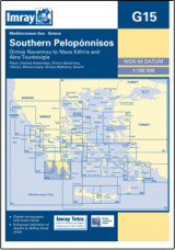
Imray G15 Jižní Peloponés
Imray G15 Southern Pelopónnisos
Scale: 1:190 000 WGS 84
Imray
Edition date 2018
Printed and corrected to August 2018
Chart scale 1:190 000
Plans included:
Liménas Kalamátas (1:12 500)
Yíthion (1:12 500)
Órmos Kapsáli (1:5000)
Dhiakofti (1:12 500)
Monemvasía (Yéfira) (1:7500)
Nísos Andikíthera to Nísos Kríti (1:190 000)
On this 2018 edition the chart specification has been improved to show coloured light flashes. The chart has been reschemed and is now portrait so to include the passage to Crete. The overlap with adjoining chart G16 has been reduced so G15 now shows the area Kalámata to Nísos Kríti and Ákra Tourkovigla. The latest harbour works at Yíthion are included as are the completed harbour works at Monemvasía (Yéfira). The harbour plan of Koróni is not included in this edition. There has been general updating throughout.
Kategorie
Partneři
![]()