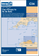
Imray C34 Cap d'Erquy to Ile de Batz
| Námořní mapy | Severozápadní Evropa | Francie
Imray C34 Cap d'Erquy to Ile de Batz
Zařazení:
Námořní mapy |
Severozápadní Evropa |
Francie
Značka: Imray
Dostupnost: dotaz na dostupnost
Imray C34 Cap d'Erquy to Ile de Batz
Scale: 1:110,000 WGS 84
Imray
Plans:
Primel
Rivière Le Léguer
Trébeurden
Ploumanac'h
Anse de Perros
Perros-Guirec
Port-Blanc
Approaches to Rivière de Tréguier
Tréguier
Approaches to Rivière de Trieux and Paimpol
Port de la Corderie (Ile de Bréhat)
Port Clos (Ile de Bréhat)
Lézardrieux
Paimpol
St-Quay-Portrieux
Binic
Port du Légué
Dahouët
2009 edition includes extensive updating throughout. Some areas of the chart redrawn to improve positional accuracy. Includes latest depths in Anse de Perros and the approaches to Le Trieux. Buoyage in the approaches to Rivière de Tréguier and Le Légué fully updated.
| měřítko | 1:110000 |
Kategorie
Partneři
![]()